3
$\begingroup$

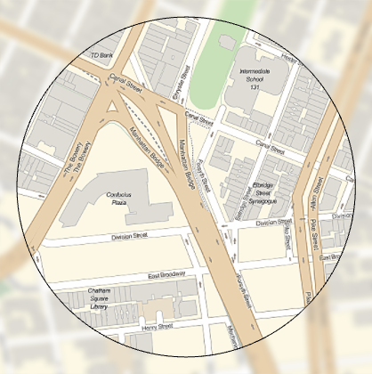
From the GeoStylingImageFunction documentation you can apply different functions to the background and to geographic areas.

GeoGraphics[{GeoStyling["StreetMap", GeoStylingImageFunction -> Sharpen], EdgeForm[Black], 
  GeoDisk[GeoPosition[{40.7148, -73.9948}], Quantity[250, "Meters"]]}, 
 GeoBackground -> 
  GeoStyling["StreetMap", GeoStylingImageFunction -> (Blur[#1, 10] & )]]
Mathematica graphics

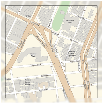
I need to do the same but with graphics primitives. The issue I am having is that primitives are not drawn with the specified GeoStyling. Instead they are drawn with default Graphics directives (i.e. Black).

GeoGraphics[{GeoStyling["StreetMap", GeoStylingImageFunction -> Sharpen], EdgeForm[Black], 
  Rectangle[GeoPosition[{40.7126, -73.9977}], GeoPosition[{40.7171, -73.9918}]]}, 
 GeoBackground -> 
  GeoStyling["StreetMap", GeoStylingImageFunction -> (Blur[#1, 10] & )]]

Mathematica graphics

What I was hoping to see is a rectangle with the sharpened image of the map within it; as is seen with the circle.

I have several locations to mark and I can use a Rectangle for all of them if that makes it easier. locs can be used as a sample of locations to try the solution.

SeedRandom[4297];
locs = GeoPosition /@ 
  Reverse[RandomPoint[
    DiscretizeGraphics[
     EntityClass["Neighborhood", "DowntownNeighborhoods::NewYork::NewYork::UnitedStates"][
      "Polygon"]], 
         5], {2}]

Ideas?

$\endgroup$

1 Answer 1

6
$\begingroup$

I found two ways:

1. GeoBoundsRegion

In case you just want a rectangle, the easiest is:

mygeoreg = GeoBoundsRegion@GeoBounds@
GeoDisk[GeoPosition[{40.7148,-73.9948}],Quantity[250,"Meters"]]

GeoGraphics[{GeoStyling["StreetMap",GeoStylingImageFunction->Sharpen],
EdgeForm[Black], mygeoreg},
GeoBackground->GeoStyling["StreetMap",GeoStylingImageFunction->(Blur[#1,10]&)]]

enter image description here

2. Polygon

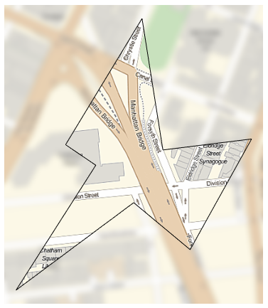
In case you want any geometric region (not only a rectangle), you can use Polygon... but there is a trick, or rather it seems to be a bug for which i found a workaround as described in this related post. The "bug" is that GeoStyling[anymapstyle ...] do only work with an arbitrary Polygon if the coordinates are globally (and not individually) wrapped with GeoPosition.

For example:

mypoly={{40.71483703495285`,-73.99605494339924`},{40.716520051111`,-73.99470827199157`},{40.71476678743837`,-73.99434102007059`},{40.71491340888779`,-73.99277933338962`},{40.71343695345883`,-73.99386079093283`},{40.71406393970131`,-73.99485503905909`},{40.71289656406121`,-73.99692746298048`},{40.714563276515705`,-73.99552263170379`}};

GeoGraphics[{GeoStyling["StreetMap",GeoStylingImageFunction->Sharpen],
EdgeForm[Black], Polygon@GeoPosition@mypoly},
GeoBackground->GeoStyling["StreetMap",GeoStylingImageFunction->(Blur[#1,10]&)]]

enter image description here

$\endgroup$
1
  • $\begingroup$ Great find with both GeoBondsRegion and the special Polygon GeoPosition format. (+1) Will wait a bit just in case. $\endgroup$
    – Edmund
    Commented Jul 22, 2017 at 0:38

Your Answer

By clicking “Post Your Answer”, you agree to our terms of service and acknowledge you have read our privacy policy.

Not the answer you're looking for? Browse other questions tagged or ask your own question.