6
$\begingroup$

I'm trying to draw markers for a list of Germany ZIP codes onto a map. Following the official documentation, it seems as if using GeoMarkeron values like

Entity["City", {"Nürnberg", "Germany"}]

should work. But Mathematica does not find any location information for German cities:

GeoGraphics[
  {GeoMarker[{Entity["City", {"Nürnberg", "Germany"}]}]}
]

Unable to obtain location information for Entity[City,{Nürnberg,Germany}].

I tried several combinations with city names and ZIP codes, but to no avail. But when I search for Nürnberg on Wolframalpha, they clearly have data on the city!

How can I draw markers from ZIP codes in German cities?

$\endgroup$

3 Answers 3

7
$\begingroup$

Entities are not meant to be typed directly. There is no way to guess the correct format. Instead, type Ctrl-=, type the name of the city in any form you like: Nürnberg or Nuremberg will both work, then hit enter. You'll see this:

Mathematica graphics

If the interpretation is not correct, you can choose another one through the ... menu. If everything if fine, you can confirm with the ✓ button (though this is not compulsory). Now you are ready to use the entity.

If you look at its full form, you will see that it is

Entity["City", {"Nuremberg", "Bavaria", "Germany"}]

The way you entered it was not correct.

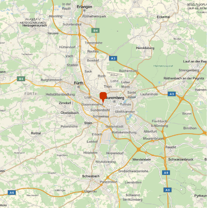
The correct form works fine in GeoMarker.

GeoGraphics[
 GeoMarker[Entity["City", {"Nuremberg", "Bavaria", "Germany"}]]
]

Mathematica graphics

Mathematica graphics

$\endgroup$
3
  • $\begingroup$ Thanks. Unfortunately, this is (in this form) useless when reading about 400 ZIP codes from a CSV. :/ I guess I could, somehow, determine the Bundesland (it's not in the data set; it's irrelevant in Germany for most purposes), but meh. $\endgroup$
    – Raphael
    Commented Sep 1, 2017 at 15:06
  • 2
    $\begingroup$ @Raphael Yes, Interpreter is good for that. I showed why your Entity didn't work. $\endgroup$
    – Szabolcs
    Commented Sep 1, 2017 at 17:18
  • 1
    $\begingroup$ Whoever downvoted: A downvote won't improve the answer but commenting about what's wrong might. $\endgroup$
    – Szabolcs
    Commented May 23, 2019 at 11:52
7
$\begingroup$

Using an external API

ClearAll[GermanZip2GeoPosition];
GermanZip2GeoPosition[zip_String] := Block[
   {response = Quiet@Import[URLBuild[{"https://api.zippopotam.us", "DE", zip}], "RawJSON"]},
   If[response =!= $Failed,
    Query["places", 1, 
      GeoPosition[ToExpression@{#["latitude"], #["longitude"]}] &][response]
    , Null
    ]
   ];
GermanZip2GeoPosition[zip_Integer] := GermanZip2GeoPosition[ToString[zip]];
SetAttributes[GermanZip2GeoPosition, Listable]

Example

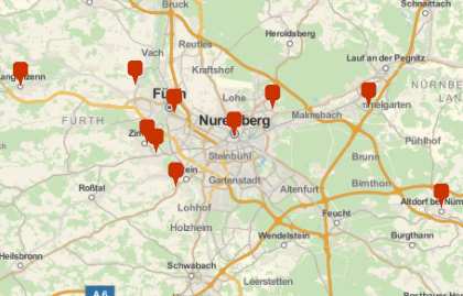
GeoGraphics@GeoMarker@GermanZip2GeoPosition@{90402, 90491, 90513, 90518, 90522, 90547, 90552, 90579, 90762, 90768
}

Mathematica graphics


Code and plots done in Mathemathica 11.1.1 on Win7

$\endgroup$
8
  • 4
    $\begingroup$ I like seeing API-based solutions a lot... :D $\endgroup$ Commented Sep 1, 2017 at 15:53
  • 2
    $\begingroup$ Thanks! This seems to work, however the choice of service is probably less than ideal for Germany. As far as I can tell from comparing the images I get, the two versions mostly agree (some markers move a little this way or that) but zippopotam.us does not know a fair number of ZIP codes. $\endgroup$
    – Raphael
    Commented Sep 1, 2017 at 16:58
  • 2
    $\begingroup$ @Raphael, if you can find a service that knows German ZIP codes and has an API, we should be able to figure out how to interface Mathematica with it. $\endgroup$ Commented Sep 2, 2017 at 2:51
  • $\begingroup$ @J.M. Sure, and this answer explains how. I upvoted it, but I felt I needed to leave a "beware caveat" comment for later visitors. $\endgroup$
    – Raphael
    Commented Sep 2, 2017 at 6:52
  • 2
    $\begingroup$ @rhermans Oh, I'm sorry I wasn't clear: I didn't expect anybody to program the perfect solution for me. I expect to be able to use any API following your example; and if not, I'd open a new question. I consider this question dealt with; I'll wait another day or two and then accept an answer. Thanks for your help! $\endgroup$
    – Raphael
    Commented Sep 2, 2017 at 7:16
6
$\begingroup$

Function Interpreter can find the positions:

Interpreter["Location"]["Nürnberg, Germany"]
Interpreter["Location"]["90402, Germany"]

Both versions return a GeoPosition value.

Starting from a list of ZIP codes, the following works:

plzs := {19258, 57399, 90402}
plzsGermany := Map[ToString[#] <> ", Germany" &, plzs]
positions := Map[Interpreter["Location"][#] &, plzsGermany]
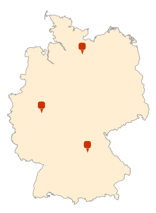
GeoGraphics[
  {
    GeoStyling["OutlineMap"], 
    Polygon[Entity["Country", "Germany"]], 
    GeoMarker[positions]
  }, 
  GeoBackground -> Transparent
]

enter image description here

The approach works with city names as well, and should generalize to other countries.

Warning: Applied to long lists of zip codes, this can run a while.

$\endgroup$
6
  • 4
    $\begingroup$ Beware! Interpreter["Location"] does return GeoPosition from some UK Postcodes, (Interpreter["Location"] ["NW6 1PG"] returns GeoPosition[{51.5472, -0.191049}]) but sometimes fails ( Interpreter["Location"] ["NW6 1EH"] returns failure message "No geographic location interpretation found. Try again"). This was reported in CASE:3913717, the response was that developers "haven't optimized interpreter to handle these inputs. Further conversion of these postal codes to GeoPositions would require a custom interpreter". It may fail for Germany too. $\endgroup$
    – rhermans
    Commented Sep 1, 2017 at 14:16
  • $\begingroup$ @rhermans Yes, some ZIPs failed. Out of the three error messages I got, one was a PO box and two were not even known to Deutsche Post, so I blame my data set. That said, I did add germanPositions := Select[positions, GeoWithinQ[Entity["Country", "Germany"], #] &] to avoid bad/undesired positions. $\endgroup$
    – Raphael
    Commented Sep 1, 2017 at 15:04
  • $\begingroup$ @rhermans Thanks for the warning, anyway! While an approximation of the full data set is fine for my purposes, others may require more precision. $\endgroup$
    – Raphael
    Commented Sep 1, 2017 at 15:04
  • 2
    $\begingroup$ At least in the UK, the postal codes that did return GeoPositions were not necessarily accurate. I find it particularly worrisome that this creates the illusion that works, but in reality, translating postal code to GeoPositions is not officially supported, and performance is random. $\endgroup$
    – rhermans
    Commented Sep 1, 2017 at 15:11
  • 1
    $\begingroup$ The inaccuracies of GeoPositions I noticed in London UK, was on the order of hundred of meters, not relevant to countrywide scale. $\endgroup$
    – rhermans
    Commented Sep 1, 2017 at 17:59

Your Answer

By clicking “Post Your Answer”, you agree to our terms of service and acknowledge you have read our privacy policy.

Not the answer you're looking for? Browse other questions tagged or ask your own question.