As Sjoerd shows, AstronomicalData[] can be used to determine the altitude of the sun. However, if you do not need too much accuracy, such as in this application, you can use a low-accuracy method for computing the altitude. Most of the formulae I will be using are from (of course) Jean Meeus's Astronomical Algorithms.
Some auxiliary routines will be needed. First, one for computing the Julian Day number:
Options[jd] = {"Calendar" -> "Gregorian"};

jd[{yr_Integer, mo_Integer, da_?NumericQ, rest___}, opts : OptionsPattern[]] :=
  Module[{y = yr, m = mo, h}, If[m < 3, y--; m += 12];
         h = Switch[OptionValue["Calendar"],
                    "Gregorian", (Quotient[#, 4] - # + 2) &[Quotient[y, 100]],
                    "Julian", 0,
                    _, Return[$Failed]];
         Floor[365.25 y] + Floor[30.6001 (m + 1)] + da +
         FromDMS[PadRight[{rest}, 3]]/24 + 1720994.5 + h]

jd[opts : OptionsPattern[]] := jd[DateList[], opts]
Here's a method for computing the Greenwich Mean Sidereal Time:
GMST[{yr_Integer, mo_Integer, da_?NumericQ, rest___}, opts : OptionsPattern[]] :=
    Mod[6.697374558 + 0.06570982441908 (jd[{yr, mo, da}, opts] - 2.451545*^6) +
    1.00273790935 FromDMS[PadRight[{rest}, 3]] + 0.000026 ((jd[{yr, mo, da, rest}, opts] -
    2.451545*^6)/36525)^2, 24]

GMST[opts : OptionsPattern[]] := GMST[DateList[], opts]
Finally, here's the low-accuracy method for computing the solar altitude:
solarAltitude[date_List, {ϕ_, λ_}] :=
 Module[{t, ℳ☉, ℯ, s, ℰ, v, Ω, ℒ0, Λ, ε, α, δ, ℋ},

  t = (jd[date] - 2451545)/36525;

  (* ℳ☉ - mean solar anomaly *)
  ℳ☉ = Mod[(1.28710479305*^6 + t (1.295965810481*^8 + t (-0.5532 + t (1.36*^-4 -
            1.149*^-5 t))))/3600, 360] °;

  (* ℯ - eccentricity of Earth's orbit *)
  ℯ = 0.0167086342 + t (-0.004203654 + t (-0.00126734 +
      t (1.444*^-4 + t (-2.*^-6 + 3.*^-5 t))));

  (* ℰ - eccentric anomaly; approximate solution of Kepler's equation *)
  s = Sin[ℳ☉]; ℰ = ℳ☉ + ℯ s/(s - Sin[ℳ☉ + ℯ] + 1);

  (* v - true anomaly *)
  v = 2 ArcTan[Sqrt[(1 + ℯ)/(1 - ℯ)] Tan[ℰ/2]]/°;

  (* ℒ0 - geometric mean longitude *)
  ℒ0 = (280.46645 + t (36000.76983 + 3.032*^-4 t));

  (* Ω - Meeus's correction for apparent angles *)
  Ω = (125.04 - 1934.136 t) °;

  (* Λ - solar longitude, plus correction for apparent position *)
  Λ = Mod[v + ℒ0 - ℳ☉/°, 360] ° - (0.00569 + 0.00478 Sin[Ω]) °;

  (* ε - mean obliquity of the ecliptic, plus correction for apparent position *)
  ε = (84381.406 + t (-46.836769 + t (-1.831*^-4 + t (0.0020034 +
      t (-5.76*^-7 - 4.34*^-8 t))))) °/3600 + 0.00256 Cos[Ω] °;

  (* α - right ascension, δ - declination *)
  {α, δ} = {ArcTan[Cos[Λ], Sin[Λ] Cos[ε]]/(15 °), ArcSin[Sin[ε] Sin[Λ]]};

  (* ℋ - hour angle *)
  ℋ = 15 ° Mod[FromDMS[GMST[date]] + λ/15 - α, 24];

  ArcSin[Sin[δ] Sin[ϕ °] + Cos[δ] Cos[ϕ °] Cos[ℋ]]/°]
A few nice maps:
earthDay = Import["https://i.sstatic.net/KLrc8.jpg"];
earthNight = Import["https://i.sstatic.net/mCJik.jpg"];
Finally, the routine for making a day/night map:
Options[DayAndNightMap] = {Sphere -> False, TimeZone :> $TimeZone};

DayAndNightMap[date_List, opts : OptionsPattern[]] :=
   Module[{h = OptionValue[TimeZone], terminator, dayAndNight},
          terminator = Binarize[
          RegionPlot[Positive[solarAltitude[DatePlus[date, {-h, "Hour"}], {ϕ, λ}]],
                     {λ, -180, 180}, {ϕ, -90, 90}, AspectRatio -> Automatic,
                     BoundaryStyle -> None, Frame -> False, ImagePadding -> None,
                     ImageSize -> {2048, 1024}, PlotPoints -> 45,
                     PlotRangePadding -> None, PlotStyle -> Black]];

          dayAndNight = RemoveAlphaChannel[ImageCompose[earthDay,
                        SetAlphaChannel[earthNight, terminator]]];

          If[TrueQ[OptionValue[Sphere]],
             ParametricPlot3D[{Cos[λ] Sin[ϕ], Sin[λ] Sin[ϕ], Cos[ϕ]},
                              {λ, -π, π}, {ϕ, 0, π}, Axes -> None, Boxed -> False,
                              Lighting -> "Neutral", Mesh -> None, PlotPoints -> 55,
                              PlotStyle -> Texture[dayAndNight], RotationAction -> "Clip",
                              TextureCoordinateFunction -> ({#4, 1 - #5} &)],
             dayAndNight]]

DayAndNightMap[opts : OptionsPattern[]] := DayAndNightMap[DateList[], opts]
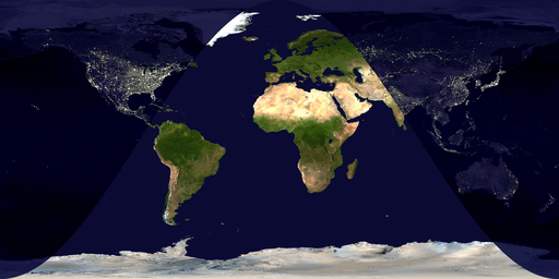
I guess an example is in order at this point:
DayAndNightMap[{2013, 5, 21, 15, 30, 0}, TimeZone -> 0]

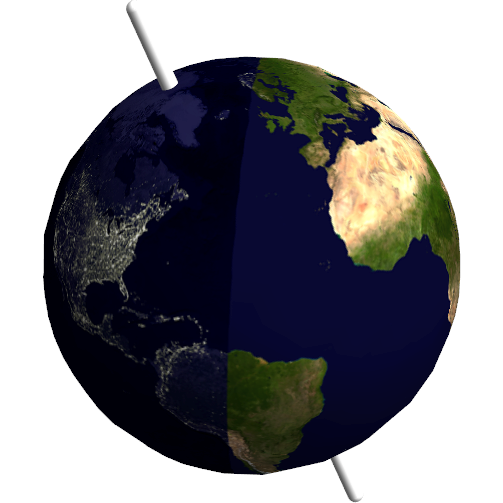
For the kids who prefer actual globes:
DayAndNightMap[{2013, 5, 21, 15, 30, 0}, Sphere -> True, TimeZone -> 0]
