Randomly-colored map
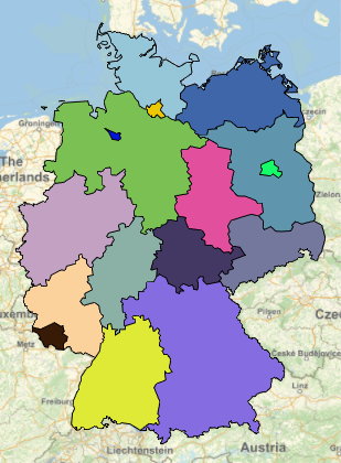
Let's start with a colored map of the first level of administrative divisions for a country. We'll use Germany, but any country that has curated data for administrative divisions and their polygons will work. For Germany, these divisions are the Bundesländer.
country = Entity["Country", "Germany"];
regions =
  EntityList[
    country[EntityProperty["Country", "AdministrativeDivisions"]]];
For the regions that don't have polygons, the map will display dots at the center of each region. Here's a map with a random color for each region. Tooltip allows you to move the cursor over the map to see the names of the regions.
SeedRandom[1234];
randomColors =
  Normal@AssociationThread[regions, RandomColor[Length[regions]]];
GeoGraphics[{EdgeForm[
   Directive[Thin,
    Black]], {GeoStyling[#2],
     Tooltip[Polygon[#1],
      StringReplace[#1["Name"], "," ~~ __ -> ""]]} & @@@
   randomColors}]

Four-color theorem map and border entity list
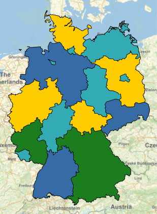
Another way to color the regions is to assign colors by solving the four-color theorem. We need to know the regions that have common borders. Unfortunately, except for the United States, the curated data doesn't list the bordering regions for country administrative divisions. However, we can make a list from the regions' polygons. This method will work for any country if the regions have polygons.
Build a list of regions and match the other regions that have a common border.
Again, we start with the list of administrative division regions.
- Make a matrix of the distance between borders for the regions using
GeoDistance.
- Use the matrix to create an adjacency list with self-to-self references removed, e.g. {1, 1} is deleted. For any region with no bordering regions (i.e., islands), insert a place-holder with
Null as the adjacent region.
- Cross reference the positions in
adjacencyList to region entities, and apply the entities to the list.
- Use
GroupBy to collect each region with a list of the regions with common borders to create borderEntityList.
country = Entity["Country", "Germany"];
regions =
  EntityList[
   country[EntityProperty["Country", "AdministrativeDivisions"]]];
boundaryDistanceMatrix = GeoDistance[regions, regions];
adjacencyList =
  Cases[Position[QuantityMagnitude[boundaryDistanceMatrix], 0.],
   Except[{n_, n_}]];
If[Length@regions !=
   Length@DeleteDuplicates[adjacencyList[[All, 1]]],
  adjacencyList = Sort@Join[adjacencyList,
     Partition[
      Rest@Riffle[
        Complement[Range[Length@regions],
          DeleteDuplicates[adjacencyList[[All, 1]]]], {Null},
        {1, -1, 2}], 2]]];
entityMap = AssociationThread[Range[Length[regions]], regions];
borderEntityList =
  Normal@GroupBy[adjacencyList /. entityMap,
     First -> Last] /. {Null} -> {};
We can use the border entity list to assign colors. I modified a method from Wolfram Community to find color assignments that are a solution to the four-color theorem.
(*choose four contrasting colors*)
fourColors = {RGBColor[.2, .67, .7], RGBColor[.21, .42, .65],
  RGBColor[1.0, .8, 0.0], RGBColor[.11, .49, .12]};
borderingregions = Values@borderEntityList;
neighbors =
  Transpose[{regions,
    Intersection[#, regions] & /@ borderingregions}];
toColor[tf_] := fourColors[[
   Switch[tf,
    {False, False}, 1, {False, True}, 2,
    {True, False}, 3, {True, True}, 4,
    _, Null
    ]]]
eqs = And @@ (Flatten[
     Function[{c, n},
       BooleanConvert[Xor[x[c], x[#]] || Xor[y[c], y[#]], "CNF"] & /@
        n] @@@ neighbors]);
solution =
  Join[First[
    FindInstance[eqs, Union[Cases[eqs, _x | _y, \[Infinity]]],
     Booleans]],
   Flatten[{x[#] -> True, y[#] -> True} & /@
     Flatten[Cases[neighbors, {_, {}}]]]];
colorAssignments = (#[[1, 1, 1]] -> toColor[Last /@ #]) & /@
   Partition[SortBy[solution , #[[1, 1]] &], 2];
Draw a four-color map
GeoGraphics[{EdgeForm[
   Directive[Thin,
    Black]], {GeoStyling[#2],
     Tooltip[Polygon[#1],
      StringReplace[#1["Name"], "," ~~ __ -> ""]]} & @@@
   colorAssignments}]

Border entity list demonstrations
Table of regions and number of bordering regions
TableForm[{StringReplace["," ~~ __ -> ""]@CommonName@First@#,
    Length[Last@#]} & /@ borderEntityList,
 TableHeadings -> {None, {"Region", "Bordering"}}]
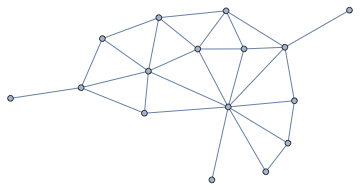
Graph of adjacent regions
borderingQ[r1_, r2_] := MemberQ[r1 /. borderEntityList, r2]
RelationGraph[borderingQ, regions]

Notes
- The first level of administrative-division regions for most countries
have subdivisions. We can get a list of subdivisions, but the curated
data doesn't have polygons, so they can't be mapped as outlines. If you have a set of latitude and longitude coordinates for the regions' outlines, you can convert them to polygons for Mathematica.
subdivisions =
  EntityValue[regions, "Subdivisions", "EntityAssociation"];
EntityValue[Flatten@Values@subdivisions, "HasPolygon"]~AnyTrue~TrueQ
(* False *)
How do you find out for which keywords there are geographical data in the Wolfram database?
- The "keywords" are properties of entity types.
Here's a list of the properties for the "Country" entity type.
EntityProperties["Country"] // CanonicalName
- The subdivisions belong to entity type "AdministrativeDivision".
Here's a list of the properties.
EntityProperties["AdministrativeDivision"] // CanonicalName


GeoGraphics[Flatten[{RandomColor[], Polygon@#} & /@ Entity["Country", "Germany"][EntityProperty["Country", "AdministrativeDivisions"]]]]$\endgroup$Entity["AdministrativeDivision", {"Thuringia", "Germany"}][ EntityProperty["AdministrativeDivision", "BorderingStates"]]to work, but it does not. If it did, this could be directly generalized: mathematica.stackexchange.com/a/161343/12 $\endgroup$AdministrativeDivisionAdjacentQeasily usingGeoDistance[{a, b}, DistanceFunction -> "Boundary"]and use that to fill the blanks... $\endgroup$