deleted 531 characters in body
Source Link
Rod
  • 3.3k
  • 2
  • 25
  • 41

This is only an attempt to answer the question, if I understood it correctly. You want to "cover the actual road connection between cities (...) based on the GoogleMap".

First step: find the coordinates of the two cities you want to use as edges in your graphic:

c1 = CityData["Uppsala"CityData["Sao Paulo", "Coordinates"]"Coordinates"];
c2 = CityData["Marsta"CityData["Rio de Janeiro", "Coordinates"]"Coordinates"];

{59.86, 17.64}

{59.63, 17.84}

Second step: define the center of the map:

center = (c1 + c2)/22;

{59.745, 17.74}

Third step: Import[] the actual Google Maps image based on the center you've specified

g1=Import["httpImport["http://maps.google.com/maps/api/staticmap?center="<>ToString[center[[1]]]<>"center=" <>ToString[center[[1]]] <> "," <>ToString[center[[2]]]<>"&zoom=10&size=400x400&sensor=false&maptype=roadmap"]<> ToString[center[[2]]] <> "&zoom=6&size=400x400&sensor=false&maptype=roadmap&markers=color:blue%7Clabel:O%7C" <> ToString[c1[[1]]] <> "," <> ToString[c1[[2]]] <>"&markers=color:red%7Clabel:D%7C" <> ToString[c2[[1]]] <> "," <> ToString[c2[[2]]]]
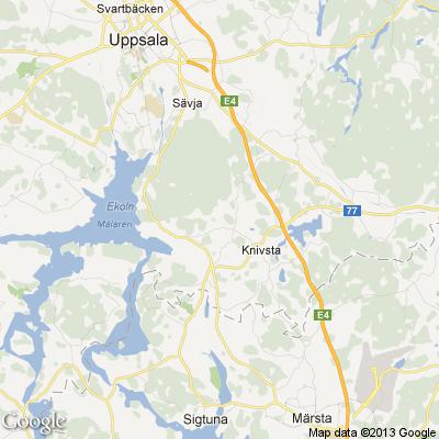
enter image description here

I'm still wondering what exactly you want with "set the calculated distance as EdgeCost value of created edge"...enter image description here
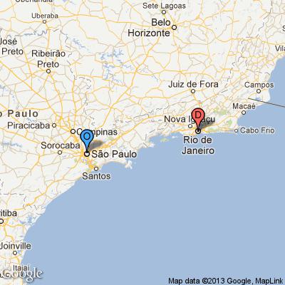
EDITED

After some research, I think it can also be done:

Define the cities:

from = ToString[c1[[1]]] <> "," <> ToString[c1[[2]]];
to = ToString[c2[[1]]] <> "," <> ToString[c2[[2]]];

Now use Mathematica to import data from Google with distance and time:

distdata = Import["http://maps.googleapis.com/maps/api/directions/json?origin=" <> from <> "&destination=" <> to <> "&region=es&sensor=false", {"HTML", "Source"}];

Now find distance by road:

roadDistance = StringSplit[StringSplit[distdata, ":"][[13]],","][[1]]

"35.3"429 km"

Now find travel time:

travelTime = StringSplit[StringSplit[distdata, ":"][[16]], ","][[1]]

"30 mins"

EDITED

Now put everything together.

First define graphic with markers...

Import["http://maps.google.com/maps/api/staticmap?center=" <>ToString[center[[1]]] <> "," <> ToString[center[[2]]] <> "&zoom=10&size=400x400&sensor=false&maptype=roadmap&markers=color:blue%7Clabel:O%7C" <> ToString[c1[[1]]] <> "," <> ToString[c1[[2]]] <>"&markers=color:red%7Clabel:D%7C" <> ToString[c2[[1]]] <> "," <> ToString[c2[[2]]]]
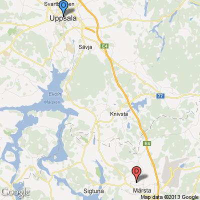
enter image description here

and

{roadDistance,travelTime}

{"35.3 km","30"4 hours 44 mins"}

This is only an attempt to answer the question, if I understood it correctly. You want to "cover the actual road connection between cities (...) based on the GoogleMap".

First step: find the coordinates of the two cities you want to use as edges in your graphic:

c1 = CityData["Uppsala", "Coordinates"]
c2 = CityData["Marsta", "Coordinates"]

{59.86, 17.64}

{59.63, 17.84}

Second step: define the center of the map:

center = (c1 + c2)/2

{59.745, 17.74}

Third step: Import[] the actual Google Maps image based on the center you've specified

g1=Import["http://maps.google.com/maps/api/staticmap?center="<>ToString[center[[1]]]<>"," <>ToString[center[[2]]]<>"&zoom=10&size=400x400&sensor=false&maptype=roadmap"]

enter image description here

I'm still wondering what exactly you want with "set the calculated distance as EdgeCost value of created edge"...

EDITED

After some research, I think it can also be done:

Define the cities:

from = ToString[c1[[1]]] <> "," <> ToString[c1[[2]]];
to = ToString[c2[[1]]] <> "," <> ToString[c2[[2]]];

Now use Mathematica to import data from Google with distance and time:

distdata = Import["http://maps.googleapis.com/maps/api/directions/json?origin=" <> from <> "&destination=" <> to <> "&region=es&sensor=false", {"HTML", "Source"}];

Now find distance by road:

roadDistance = StringSplit[StringSplit[distdata, ":"][[13]],","][[1]]

"35.3 km"

Now find travel time:

travelTime = StringSplit[StringSplit[distdata, ":"][[16]], ","][[1]]

"30 mins"

EDITED

Now put everything together.

First define graphic with markers...

Import["http://maps.google.com/maps/api/staticmap?center=" <>ToString[center[[1]]] <> "," <> ToString[center[[2]]] <> "&zoom=10&size=400x400&sensor=false&maptype=roadmap&markers=color:blue%7Clabel:O%7C" <> ToString[c1[[1]]] <> "," <> ToString[c1[[2]]] <>"&markers=color:red%7Clabel:D%7C" <> ToString[c2[[1]]] <> "," <> ToString[c2[[2]]]]

enter image description here

and

{roadDistance,travelTime}

{"35.3 km","30 mins"}

This is only an attempt to answer the question, if I understood it correctly. You want to "cover the actual road connection between cities (...) based on the GoogleMap".

First step: find the coordinates of the two cities you want to use as edges in your graphic:

c1 = CityData["Sao Paulo", "Coordinates"];
c2 = CityData["Rio de Janeiro", "Coordinates"];

Second step: define the center of the map:

center = (c1 + c2)/2;

Third step: Import[] the actual Google Maps image based on the center you've specified

Import["http://maps.google.com/maps/api/staticmap?center=" <>ToString[center[[1]]] <> "," <> ToString[center[[2]]] <> "&zoom=6&size=400x400&sensor=false&maptype=roadmap&markers=color:blue%7Clabel:O%7C" <> ToString[c1[[1]]] <> "," <> ToString[c1[[2]]] <>"&markers=color:red%7Clabel:D%7C" <> ToString[c2[[1]]] <> "," <> ToString[c2[[2]]]]

enter image description here

EDITED

After some research, I think it can also be done:

Define the cities:

from = ToString[c1[[1]]] <> "," <> ToString[c1[[2]]];
to = ToString[c2[[1]]] <> "," <> ToString[c2[[2]]];

Now use Mathematica to import data from Google with distance and time:

distdata = Import["http://maps.googleapis.com/maps/api/directions/json?origin=" <> from <> "&destination=" <> to <> "&region=es&sensor=false", {"HTML", "Source"}];

Now find distance by road:

roadDistance = StringSplit[StringSplit[distdata, ":"][[13]],","][[1]]

"429 km"

Now find travel time:

travelTime = StringSplit[StringSplit[distdata, ":"][[16]], ","][[1]]

"4 hours 44 mins"

added 618 characters in body
Source Link
Rod
  • 3.3k
  • 2
  • 25
  • 41

This is only an attempt to answer the question, if I understood it correctly. You want to "cover the actual road connection between cities (...) based on the GoogleMap".

First step: find the coordinates of the two cities you want to use as edges in your graphic:

c1 = CityData["Uppsala", "Coordinates"]
c2 = CityData["Marsta", "Coordinates"]

{59.86, 17.64}

{59.63, 17.84}

Second step: define the center of the map:

center = (c1 + c2)/2

{59.745, 17.74}

Third step: Import[] the actual Google Maps image based on the center you've specified

Import["httpg1=Import["http://maps.google.com/maps/api/staticmap?center="<>ToString[center[[1]]]<>"," <>ToString[center[[2]]]<>"&zoom=10&size=400x400&sensor=false&maptype=roadmap"]

enter image description here

I'm still wondering what exactly you want with "set the calculated distance as EdgeCost value of created edge"...

EDITED

After some research, I think it can also be done:

Define the cities:

from = "Uppsala";ToString[c1[[1]]] <> "," <> ToString[c1[[2]]];
to = "Marsta";ToString[c2[[1]]] <> "," <> ToString[c2[[2]]];

Now use Mathematica to import datdata from Google with distance and time:

distdata = Import["http://maps.googleapis.com/maps/api/directions/json?origin=" <> from <> "&destination=" <> to <> "&region=es&sensor=false", {"HTML", "Source"}];

Now find distance by road:

roadDistance = StringSplit[StringSplit[distdata, ":"][[13]],","][[1]]

"34"35.43 km"

Now find travel time:

travelTime = StringSplit[StringSplit[distdata, ":"][[16]], ","][[1]]

"29"30 mins"

EDITED

Now put everything together.

First define graphic with markers...

Import["http://maps.google.com/maps/api/staticmap?center=" <>ToString[center[[1]]] <> "," <> ToString[center[[2]]] <> "&zoom=10&size=400x400&sensor=false&maptype=roadmap&markers=color:blue%7Clabel:O%7C" <> ToString[c1[[1]]] <> "," <> ToString[c1[[2]]] <>"&markers=color:red%7Clabel:D%7C" <> ToString[c2[[1]]] <> "," <> ToString[c2[[2]]]]

enter image description here

and

{roadDistance,travelTime}

{"35.3 km","30 mins"}

This is only an attempt to answer the question, if I understood it correctly. You want to "cover the actual road connection between cities (...) based on the GoogleMap".

First step: find the coordinates of the two cities you want to use as edges in your graphic:

c1 = CityData["Uppsala", "Coordinates"]
c2 = CityData["Marsta", "Coordinates"]

{59.86, 17.64}

{59.63, 17.84}

Second step: define the center of the map:

center = (c1 + c2)/2

{59.745, 17.74}

Third step: Import[] the actual Google Maps image based on the center you've specified

Import["http://maps.google.com/maps/api/staticmap?center="<>ToString[center[[1]]]<>"," <>ToString[center[[2]]]<>"&zoom=10&size=400x400&sensor=false&maptype=roadmap"]

enter image description here

I'm still wondering what exactly you want with "set the calculated distance as EdgeCost value of created edge"...

EDITED

After some research, I think it can also be done:

Define the cities:

from = "Uppsala";
to = "Marsta";

Now use Mathematica to import dat from Google with distance and time:

distdata = Import["http://maps.googleapis.com/maps/api/directions/json?origin=" <> from <> "&destination=" <> to <> "&region=es&sensor=false", {"HTML", "Source"}];

Now find distance by road:

roadDistance = StringSplit[StringSplit[distdata, ":"][[13]],","][[1]]

"34.4 km"

Now find travel time:

travelTime = StringSplit[StringSplit[distdata, ":"][[16]], ","][[1]]

"29 mins"

This is only an attempt to answer the question, if I understood it correctly. You want to "cover the actual road connection between cities (...) based on the GoogleMap".

First step: find the coordinates of the two cities you want to use as edges in your graphic:

c1 = CityData["Uppsala", "Coordinates"]
c2 = CityData["Marsta", "Coordinates"]

{59.86, 17.64}

{59.63, 17.84}

Second step: define the center of the map:

center = (c1 + c2)/2

{59.745, 17.74}

Third step: Import[] the actual Google Maps image based on the center you've specified

g1=Import["http://maps.google.com/maps/api/staticmap?center="<>ToString[center[[1]]]<>"," <>ToString[center[[2]]]<>"&zoom=10&size=400x400&sensor=false&maptype=roadmap"]

enter image description here

I'm still wondering what exactly you want with "set the calculated distance as EdgeCost value of created edge"...

EDITED

After some research, I think it can also be done:

Define the cities:

from = ToString[c1[[1]]] <> "," <> ToString[c1[[2]]];
to = ToString[c2[[1]]] <> "," <> ToString[c2[[2]]];

Now use Mathematica to import data from Google with distance and time:

distdata = Import["http://maps.googleapis.com/maps/api/directions/json?origin=" <> from <> "&destination=" <> to <> "&region=es&sensor=false", {"HTML", "Source"}];

Now find distance by road:

roadDistance = StringSplit[StringSplit[distdata, ":"][[13]],","][[1]]

"35.3 km"

Now find travel time:

travelTime = StringSplit[StringSplit[distdata, ":"][[16]], ","][[1]]

"30 mins"

EDITED

Now put everything together.

First define graphic with markers...

Import["http://maps.google.com/maps/api/staticmap?center=" <>ToString[center[[1]]] <> "," <> ToString[center[[2]]] <> "&zoom=10&size=400x400&sensor=false&maptype=roadmap&markers=color:blue%7Clabel:O%7C" <> ToString[c1[[1]]] <> "," <> ToString[c1[[2]]] <>"&markers=color:red%7Clabel:D%7C" <> ToString[c2[[1]]] <> "," <> ToString[c2[[2]]]]

enter image description here

and

{roadDistance,travelTime}

{"35.3 km","30 mins"}

added 618 characters in body
Source Link
Rod
  • 3.3k
  • 2
  • 25
  • 41

This is only an attempt to answer the question, if I understood it correctly. You want to "cover the actual road connection between cities (...) based on the GoogleMap".

First step: find the coordinates of the two cities you want to use as edges in your graphic:

c1 = CityData["Uppsala", "Coordinates"]
c2 = CityData["Marsta", "Coordinates"]

{59.86, 17.64}

{59.63, 17.84}

Second step: define the center of the map:

center = (c1 + c2)/2

{59.745, 17.74}

Third step: Import[] the actual Google Maps image based on the center you've specified

Import["http://maps.google.com/maps/api/staticmap?center="<>ToString[center[[1]]]<>"," <>ToString[center[[2]]]<>"&zoom=10&size=400x400&sensor=false&maptype=roadmap"]

enter image description here

I'm still wondering what exactly you want with "set the calculated distance as EdgeCost value of created edge"...

EDITED

After some research, I think it can also be done:

Define the cities:

from = "Uppsala";
to = "Marsta";

Now use Mathematica to import dat from Google with distance and time:

distdata = Import["http://maps.googleapis.com/maps/api/directions/json?origin=" <> from <> "&destination=" <> to <> "&region=es&sensor=false", {"HTML", "Source"}];

Now find distance by road:

roadDistance = StringSplit[StringSplit[distdata, ":"][[13]],","][[1]]

"34.4 km"

Now find travel time:

travelTime = StringSplit[StringSplit[distdata, ":"][[16]], ","][[1]]

"29 mins"

This is only an attempt to answer the question, if I understood it correctly. You want to "cover the actual road connection between cities (...) based on the GoogleMap".

First step: find the coordinates of the two cities you want to use as edges in your graphic:

c1 = CityData["Uppsala", "Coordinates"]
c2 = CityData["Marsta", "Coordinates"]

{59.86, 17.64}

{59.63, 17.84}

Second step: define the center of the map:

center = (c1 + c2)/2

{59.745, 17.74}

Third step: Import[] the actual Google Maps image based on the center you've specified

Import["http://maps.google.com/maps/api/staticmap?center="<>ToString[center[[1]]]<>"," <>ToString[center[[2]]]<>"&zoom=10&size=400x400&sensor=false&maptype=roadmap"]

enter image description here

I'm still wondering what exactly you want with "set the calculated distance as EdgeCost value of created edge"...

EDITED

After some research, I think it can also be done:

Define the cities:

from = "Uppsala";
to = "Marsta";

Now use Mathematica to import dat from Google with distance and time:

distdata = Import["http://maps.googleapis.com/maps/api/directions/json?origin=" <> from <> "&destination=" <> to <> "&region=es&sensor=false", {"HTML", "Source"}];

Now find distance by road:

roadDistance = StringSplit[StringSplit[distdata, ":"][[13]],","][[1]]

"34.4 km"

Now find travel time:

travelTime = StringSplit[StringSplit[distdata, ":"][[16]], ","][[1]]

"29 mins"

Source Link
Rod
  • 3.3k
  • 2
  • 25
  • 41
Loading