add example for Madagascar
Source Link
creidhne
  • 5.8k
  • 6
  • 25
  • 32

The polygon for the African continent has 465 lists of geographic regions.

africaPolygon = Entity["GeographicRegion", "Africa"]["Polygon"]

polygon for Africa GeoGraphicRegion

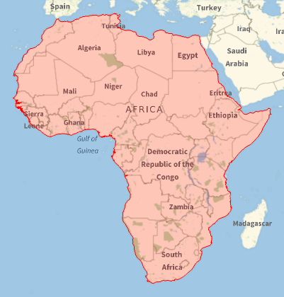
Usually, the first region is the largest, and we can select individual regions. For example, check the first region by drawing it with GeoGraphics.

geoRegion1 = Polygon[GeoPosition[africaPolygon[[1, 1, 1]]]];
GeoGraphics[{EdgeForm[Red], FaceForm[Red], geoRegion1}]

geographic region

Using GeoBoundary (introduced in version 12.2) the length of the region is:

GeoLength[GeoBoundary[geoRegion1]]
30 048. mi

Compare this value to the length of all 465 regions.

GeoLength[GeoBoundary[africaPolygon]]
43 417.6 mi

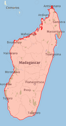
Let's repeat the method for Madagascar, and find the coastline is 4,532.34 mi.

geoRegion2 = Polygon[GeoPosition[africaPolygon[[1, 1, 2]]]];
GeoGraphics[{EdgeForm[Red], FaceForm[Red], geoRegion2}]
GeoLength[GeoBoundary[geoRegion2]]

Madagascar

The polygon for the African continent has 465 lists of geographic regions.

africaPolygon = Entity["GeographicRegion", "Africa"]["Polygon"]

polygon for Africa GeoGraphicRegion

Usually, the first region is the largest, and we can select individual regions. For example, check the first region by drawing it with GeoGraphics.

geoRegion1 = Polygon[GeoPosition[africaPolygon[[1, 1, 1]]]];
GeoGraphics[{EdgeForm[Red], FaceForm[Red], geoRegion1}]

geographic region

Using GeoBoundary (introduced in version 12.2) the length of the region is:

GeoLength[GeoBoundary[geoRegion1]]
30 048 mi

Compare this value to the length of all 465 regions.

GeoLength[GeoBoundary[africaPolygon]]
43 417.6 mi

The polygon for the African continent has 465 lists of geographic regions.

africaPolygon = Entity["GeographicRegion", "Africa"]["Polygon"]

polygon for Africa GeoGraphicRegion

Usually, the first region is the largest, and we can select individual regions. For example, check the first region by drawing it with GeoGraphics.

geoRegion1 = Polygon[GeoPosition[africaPolygon[[1, 1, 1]]]];
GeoGraphics[{EdgeForm[Red], FaceForm[Red], geoRegion1}]

geographic region

Using GeoBoundary (introduced in version 12.2) the length of the region is:

GeoLength[GeoBoundary[geoRegion1]]
30 048. mi

Compare this value to the length of all 465 regions.

GeoLength[GeoBoundary[africaPolygon]]
43 417.6 mi

Let's repeat the method for Madagascar, and find the coastline is 4,532.34 mi.

geoRegion2 = Polygon[GeoPosition[africaPolygon[[1, 1, 2]]]];
GeoGraphics[{EdgeForm[Red], FaceForm[Red], geoRegion2}]
GeoLength[GeoBoundary[geoRegion2]]
Madagascar

Source Link
creidhne
  • 5.8k
  • 6
  • 25
  • 32

The polygon for the African continent has 465 lists of geographic regions.

africaPolygon = Entity["GeographicRegion", "Africa"]["Polygon"]

polygon for Africa GeoGraphicRegion

Usually, the first region is the largest, and we can select individual regions. For example, check the first region by drawing it with GeoGraphics.

geoRegion1 = Polygon[GeoPosition[africaPolygon[[1, 1, 1]]]];
GeoGraphics[{EdgeForm[Red], FaceForm[Red], geoRegion1}]

geographic region

Using GeoBoundary (introduced in version 12.2) the length of the region is:

GeoLength[GeoBoundary[geoRegion1]]
30 048 mi

Compare this value to the length of all 465 regions.

GeoLength[GeoBoundary[africaPolygon]]
43 417.6 mi