deleted 58 characters in body
Source Link
kglr
  • 400.5k
  • 18
  • 488
  • 929
coords = First@Interpreter["StreetAddress"]["14 James Way, Cambridge MA"]; 

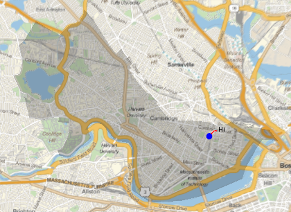
For the first part of the question, you can extract and post-process the callout graphics primitives from ListPlot[Callout[..]] and use them with GeoGraphics:

GeoGraphics[{Polygon[Entity["City", {"Cambridge", "Massachusetts", "UnitedStates"}]], 
  GeoMarker[coords, Style["\[FilledCircle]", 14, Blue]],
  Cases[ListPlot[{Callout[coords, "Hi", "CalloutStyle" -> Red]}], _GraphicsGroup, All] /. 
     Offset[a_, b_] :> Offset[a, GeoPosition[b]]}]

enter image description here

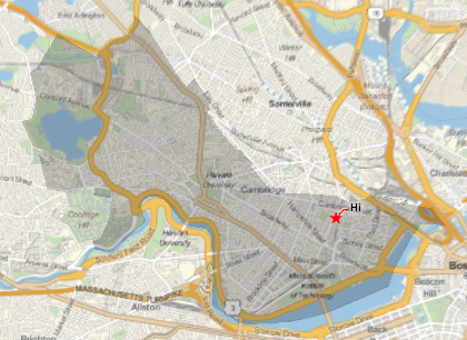
Alternatively, you can use the CalloutMarker as the GeoMarker:

GeoGraphics[{Polygon[Entity["City", {"Cambridge", "Massachusetts", "UnitedStates"}]], 
  Cases[ListPlot[{Callout[coords, "Hi", "CalloutStyle" -> Red, 
       CalloutMarker -> "Star"]}], _GraphicsGroup, All] /.
   {Offset[a_, b_] :> Offset[a, GeoPosition[b]], 
    Inset[a_, b_, c__] :> Inset[a, GeoGridPosition[GeoPosition[b], "Mercator"], c]}}]

enter image description here

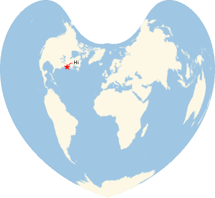
With the options GeoProjection -> {"Bonne", "Centering" -> {0, 0}} and GeoRange -> "World" we get

enter image description here

coords = First@Interpreter["StreetAddress"]["14 James Way, Cambridge MA"]; 

For the first part of the question, you can extract and post-process the callout graphics primitives from ListPlot[Callout[..]] and use them with GeoGraphics:

GeoGraphics[{Polygon[Entity["City", {"Cambridge", "Massachusetts", "UnitedStates"}]], 
  GeoMarker[coords, Style["\[FilledCircle]", 14, Blue]],
  Cases[ListPlot[{Callout[coords, "Hi", "CalloutStyle" -> Red]}], _GraphicsGroup, All] /. 
     Offset[a_, b_] :> Offset[a, GeoPosition[b]]}]

enter image description here

Alternatively, you can use the CalloutMarker as the GeoMarker:

GeoGraphics[{Polygon[Entity["City", {"Cambridge", "Massachusetts", "UnitedStates"}]], 
  Cases[ListPlot[{Callout[coords, "Hi", "CalloutStyle" -> Red, 
       CalloutMarker -> "Star"]}], _GraphicsGroup, All] /.
   {Offset[a_, b_] :> Offset[a, GeoPosition[b]], 
    Inset[a_, b_, c__] :> Inset[a, GeoGridPosition[GeoPosition[b], "Mercator"], c]}}]

enter image description here

With the options GeoProjection -> {"Bonne", "Centering" -> {0, 0}} and GeoRange -> "World" we get
enter image description here

deleted 58 characters in body
Source Link
kglr
  • 400.5k
  • 18
  • 488
  • 929
coords = First@Interpreter["StreetAddress"]["14 James Way, Cambridge MA"]; 

For the first part of the question, you can extract and post-process the callout graphics primitives from ListPlot[Callout[..]] and use them with GeoGraphics:

GeoGraphics[{Polygon[Entity["City", {"Cambridge", "Massachusetts", "UnitedStates"}]], 
  GeoMarker[coords, Style["\[FilledCircle]", 14, Blue]],
  Cases[ListPlot[{Callout[coords, "Hi", "CalloutStyle" -> Red]}], _GraphicsGroup, All] /. 
     Offset[a_, b_] :> Offset[a, GeoGridPosition[GeoPosition[b], "Mercator"]]GeoPosition[b]]}]

enter image description here

Alternatively, you can use the CalloutMarker as the GeoMarker:

GeoGraphics[{Polygon[Entity["City", {"Cambridge", "Massachusetts", "UnitedStates"}]], 
  Cases[ListPlot[{Callout[coords, "Hi", "CalloutStyle" -> Red, 
       CalloutMarker -> "Star"]}], _GraphicsGroup, All] /.
   {Offset[a_, b_] :> Offset[a, GeoGridPosition[GeoPosition[b], "Mercator"]]GeoPosition[b]], 
    Inset[a_, b_, c__] :> Inset[a, GeoGridPosition[GeoPosition[b], "Mercator"], c]}}]

enter image description here

coords = First@Interpreter["StreetAddress"]["14 James Way, Cambridge MA"]; 

For the first part of the question, you can extract and post-process the callout graphics primitives from ListPlot[Callout[..]] and use them with GeoGraphics:

GeoGraphics[{Polygon[Entity["City", {"Cambridge", "Massachusetts", "UnitedStates"}]], 
  GeoMarker[coords, Style["\[FilledCircle]", 14, Blue]],
  Cases[ListPlot[{Callout[coords, "Hi", "CalloutStyle" -> Red]}], _GraphicsGroup, All] /. 
     Offset[a_, b_] :> Offset[a, GeoGridPosition[GeoPosition[b], "Mercator"]]}]

enter image description here

Alternatively, you can use the CalloutMarker as the GeoMarker:

GeoGraphics[{Polygon[Entity["City", {"Cambridge", "Massachusetts", "UnitedStates"}]], 
  Cases[ListPlot[{Callout[coords, "Hi", "CalloutStyle" -> Red, 
       CalloutMarker -> "Star"]}], _GraphicsGroup, All] /.
   {Offset[a_, b_] :> Offset[a, GeoGridPosition[GeoPosition[b], "Mercator"]], 
    Inset[a_, b_, c__] :> Inset[a, GeoGridPosition[GeoPosition[b], "Mercator"], c]}}]

enter image description here

coords = First@Interpreter["StreetAddress"]["14 James Way, Cambridge MA"]; 

For the first part of the question, you can extract and post-process the callout graphics primitives from ListPlot[Callout[..]] and use them with GeoGraphics:

GeoGraphics[{Polygon[Entity["City", {"Cambridge", "Massachusetts", "UnitedStates"}]], 
  GeoMarker[coords, Style["\[FilledCircle]", 14, Blue]],
  Cases[ListPlot[{Callout[coords, "Hi", "CalloutStyle" -> Red]}], _GraphicsGroup, All] /. 
     Offset[a_, b_] :> Offset[a, GeoPosition[b]]}]

enter image description here

Alternatively, you can use the CalloutMarker as the GeoMarker:

GeoGraphics[{Polygon[Entity["City", {"Cambridge", "Massachusetts", "UnitedStates"}]], 
  Cases[ListPlot[{Callout[coords, "Hi", "CalloutStyle" -> Red, 
       CalloutMarker -> "Star"]}], _GraphicsGroup, All] /.
   {Offset[a_, b_] :> Offset[a, GeoPosition[b]], 
    Inset[a_, b_, c__] :> Inset[a, GeoGridPosition[GeoPosition[b], "Mercator"], c]}}]

enter image description here

added 559 characters in body
Source Link
kglr
  • 400.5k
  • 18
  • 488
  • 929
coords = First@Interpreter["StreetAddress"]["14 James Way, Cambridge MA"]; 

For the first part of the question, you can extract and post-process the callout graphics primitives from ListPlot[Callout[..]] and use them with GeoGraphics:

GeoGraphics[{Polygon[Entity["City", {"Cambridge", "Massachusetts", "UnitedStates"}]], 
  GeoMarker[coords, Style["\[FilledCircle]", 14, Blue]],
  Cases[ListPlot[{Callout[coords, "Hi", "CalloutStyle" -> Red]}], _GraphicsGroup, All] /. 
     Offset[a_, b_] :> Offset[a, GeoGridPosition[GeoPosition[b], "Mercator"]]}]

enter image description here

Alternatively, you can use the CalloutMarker as the GeoMarker:

GeoGraphics[{Polygon[Entity["City", {"Cambridge", "Massachusetts", "UnitedStates"}]], 
  Cases[ListPlot[{Callout[coords, "Hi", "CalloutStyle" -> Red, 
       CalloutMarker -> "Star"]}], _GraphicsGroup, All] /.
   {Offset[a_, b_] :> Offset[a, GeoGridPosition[GeoPosition[b], "Mercator"]], 
    Inset[a_, b_, c__] :> Inset[a, GeoGridPosition[GeoPosition[b], "Mercator"], c]}}]

enter image description here

coords = First@Interpreter["StreetAddress"]["14 James Way, Cambridge MA"]; 

For the first part of the question, you can extract and post-process the callout graphics primitives from ListPlot[Callout[..]] and use them with GeoGraphics:

GeoGraphics[{Polygon[Entity["City", {"Cambridge", "Massachusetts", "UnitedStates"}]], 
  GeoMarker[coords, Style["\[FilledCircle]", 14, Blue]],
  Cases[ListPlot[{Callout[coords, "Hi", "CalloutStyle" -> Red]}], _GraphicsGroup, All] /. 
     Offset[a_, b_] :> Offset[a, GeoGridPosition[GeoPosition[b], "Mercator"]]}]

enter image description here

Alternatively, you can use the CalloutMarker as the GeoMarker:

GeoGraphics[{Polygon[Entity["City", {"Cambridge", "Massachusetts", "UnitedStates"}]], 
  Cases[ListPlot[{Callout[coords, "Hi", "CalloutStyle" -> Red, 
       CalloutMarker -> "Star"]}], _GraphicsGroup, All] /.
   {Offset[a_, b_] :> Offset[a, GeoGridPosition[GeoPosition[b], "Mercator"]], 
    Inset[a_, b_, c__] :> Inset[a, GeoGridPosition[GeoPosition[b], "Mercator"], c]}}]

enter image description here

added 44 characters in body
Source Link
kglr
  • 400.5k
  • 18
  • 488
  • 929
Loading
added 62 characters in body
Source Link
kglr
  • 400.5k
  • 18
  • 488
  • 929
Loading
Source Link
kglr
  • 400.5k
  • 18
  • 488
  • 929
Loading